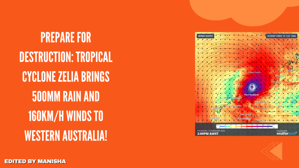
Residents in Western Australia have been warned to prepare for heavy rainfall exceeding 500mm and powerful winds as Tropical Cyclone Zelia heads toward the coast.
At 11am (AWST), the cyclone strengthened into a Category 2 system, with sustained winds reaching 95km/h and gusts up to 130km/h. The system is currently located about 180km north of Port Hedland and is moving slowly towards the coastline.
James Ashley, the Bureau of Meteorology’s state manager for Western Australia, said the cyclone is expected to shift slightly westward before resuming its southward movement tomorrow. He added that the system is moving erratically and slowly along the Pilbara coast.
The cyclone is anticipated to escalate into a Category 3 before it crosses the eastern Pilbara or western Kimberley coast on Friday. The Bureau of Meteorology has warned that areas along its path could receive more than 500mm of rain throughout the event.
The system poses a significant storm tide risk for residents between Port Hedland and Bidyadanga, with rising tides and dangerous flooding expected in low-lying coastal areas. Meteorologists also cautioned of strong gales and damaging wind gusts of 120km/h near the coastal regions between De Grey and Wallal Downs, which may extend to Port Hedland and Karratha by today.
If the cyclone shifts westward beyond the forecast, damaging winds could spread to Mardie by late tomorrow. There is also a risk of wind gusts up to 120km/h reaching inland areas, including Nullagine by Friday.
Destructive wind gusts of up to 160km/h could develop between Whim Creek and Wallal Downs tomorrow as Zelia nears the coast, with the potential for even stronger winds of up to 220km/h in the same area by tomorrow evening.
A flood watch has been issued for the Pilbara and western Kimberley catchments. For the latest updates and safety advice, residents are urged to visit the Bureau of Meteorology website.